G2150
Private Drinking Water Wells: Water Sources
This publication is one of six in a series designed to help rural families understand and manage their private drinking water wells.
Sharon O. Skipton, Extension Water Quality Educator
William L. Kranz, Extension Irrigation Specialist
Jan R. Hygnstrom, Extension Project Manager
Wayne Woldt, Extension Water and Environment Specialist
- The Hydrologic Cycle
- Occurrence of Groundwater
- Groundwater Throughout Nebraska
- How Groundwater Moves
- How Do Wells Work?
- Summary
- Acknowledgments
Groundwater provides approximately 85 percent of the water used for human consumption in Nebraska, yet the existence, movement, quantity, and quality of groundwater remains a mystery to many. For example, some think groundwater is stored in a vast underground lake, and others believe Nebraska’s groundwater comes from the Rocky Mountains, flowing in underground rivers. These notions are incorrect.
The Hydrologic Cycle
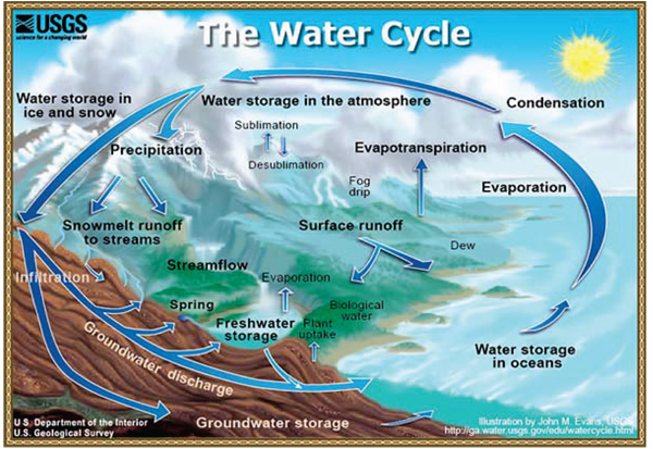
The hydrologic cycle (Figure 1) describes the constant movement of water above, on, and below the earth’s surface. Water may be in liquid, solid, or gaseous states in the cycle. Condensation, evaporation, and freezing of water occur in the cycle in response to the earth’s climatic conditions.
 |
| Figure 1. The hydrologic cycle (USGS). |
The hydrologic cycle begins with water evaporation from the earth’s soil, plant, and water surfaces to form water vapor. The sun provides energy needed to vaporize the water, and the vast majority of evaporation occurs from the oceans. The U.S. Geological Survey estimates that 39 inches of water evaporate annually from each acre of ocean surface.
Water vapor is drawn into the atmosphere by temperature gradients and can be transported over hundreds of miles by large air masses. When water vapor cools, it condenses to form clouds. As water condenses within clouds, water droplets increase in size until they fall to the earth’s surface as precipitation such as rain, hail, sleet, or snow.
Precipitation amounts vary from east to west across Nebraska. Long-term average annual precipitation varies from nearly 35 inches near Falls City in southeast Nebraska to 14 inches near Scottsbluff in western Nebraska. The statewide average annual precipitation is 20 inches.
Approximately 70 to 90 percent of the water that falls to the earth’s surface enters the soil. Although this water can become groundwater, most of it evaporates from the soil surface or is used by vegetation.
Once in the ground, water moves slowly, often remaining in storage for long periods. Water that passes through the root zone may continue to move downward to reach groundwater. The distance water has to travel to reach groundwater can range from a few feet to hundreds of feet. Water movement toward groundwater may take hours or years, depending on the depth to groundwater and the soil characteristics. In some situations, groundwater may move into surface waters such as lakes or streams. For example, groundwater flow from springs is a primary source of water for rivers originating in the Sandhills.
Occurrence of Groundwater
In most areas of the world, and specifically in Nebraska, water does not flow in and is not stored in large underground lakes or rivers. Groundwater is stored in the spaces and cracks called voids, between particles of soil, sand, gravel, rock, or other material. These materials form what is sometimes called the groundwater aquifer or reservoir. Nebraska has a vast supply of excellent quality groundwater. The University of Nebraska–Lincoln Conservation and Survey Division has estimated Nebraska has 2 billion acre-feet of groundwater in storage, or approximately 25 times the state’s average annual precipitation. If all the water stored as groundwater in Nebraska were removed, it would cover the state with approximately 40 feet of water.
Groundwater Throughout Nebraska
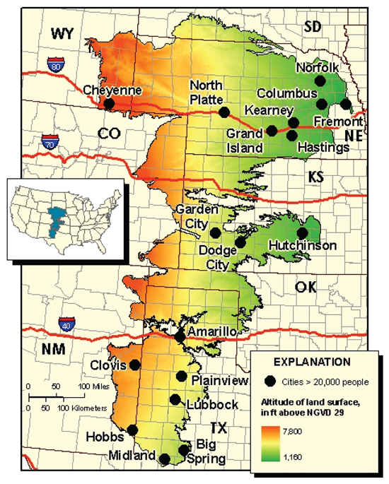
The majority of the groundwater found in Nebraska is in the Ogallala aquifer, which extends from south central South Dakota through central and western Nebraska, to Texas. Groundwater in eastern Nebraska is not part of that aquifer. The aquifer over the entire area is known as the High Plains aquifer. Portions of the High Plains aquifer that are in the Ogallala aquifer are referred to as the Ogallala Group (Figure 2).
 |
| Figure 2. The High Plains aquifer (USGS). |
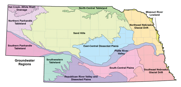
Nebraska’s groundwater geology were broken down into 13 groundwater regions (Figure 3). Within each region, groundwater occurs under similar conditions. The boundaries between regions, in general, represent zones of gradual change. Site-specific investigations are needed to determine the water supply of any specific site. The UNL Conservation and Survey Division and the Nebraska Well Drillers Association describe each region as follows.
 |
| Figure 3. Thirteen groundwater regions in Nebraska (UNL Conservation and Survey Division). |
Sand Hills — Large yields of good quality water can be obtained from the High Plains aquifer. Sand and sandstones of the Ogallala Group, a large part of the High Plains aquifer, underlie the entire region but become thin toward the east. Runoff rarely occurs because precipitation readily infiltrates the sandy soil.
Platte River Valley — In most parts of the region, high yields of good quality water can be obtained from sand and gravel deposited during the last 1.6 million years. Sand and sandstones of the Ogallala Group underlie parts of the North Platte River Valley, South Platte River Valley, and Platte River Valley as far east as Grand Island. Concentrations of dissolved solids in groundwater range from 500 to more than 1,000 milligrams per liter in the shallow aquifer throughout most of the western two-thirds of the region. The highest concentrations occur in the South Platte River valley.
Missouri River Lowlands — High-yield wells can be developed in the sand and gravel aquifer. Groundwater is more mineralized than that in the Lower Platte River valley, and iron and manganese concentrations may be higher than desired.
South-Central Plains — Abundant groundwater can be found in this region. In the eastern part of this region, sand and gravel yield large amounts of good quality water, while in the west, sandstones are the source.
Southwestern Tablelands — Sandstone, sand, and gravel have been developed extensively. Pumping lifts of 200 feet or more are common.
Northern Panhandle and Southern Panhandle Tablelands — Thick layers of moderately permeable siltstone, sand, sandstone, and gravel underlie the tablelands. Wells usually are several hundred feet deep, and those of large capacity generally are restricted to areas underlain by coarse-grained sediments. Rocks beside major drainage courses usually are not saturated. In the Southern Panhandle Tablelands, wells also derive water from fractures in the siltstone under the valleys of Pumpkin and Lodgepole creeks and in Sidney Draw.
East-Central Dissected Plains — Ogallala Group deposits underlie the western two-thirds of the region, becoming thinner toward the east. In the central and eastern parts of the region, sand and gravel deposits, covered by loess (windblown silt, or dust), are thickest within ancient buried river valleys. Water quality is generally good.
Northeast Nebraska and Southeast Nebraska Glacial Drift — Glacial till, locally known as boulder clay, or sometimes as rock flour, is of low permeability and covers most of the region. Beneath these deposits, sand and gravel in ancient buried valleys and along stream valleys are one source of groundwater. Shales and sandstones underlie much of the region as bedrock, except for the southeastern part of the Southeast Nebraska Glacial Drift area, where older shales and limestones are the bedrock. Sandstone is an important aquifer in some places; however, in some locations, the groundwater can be slightly to very salty. These sandstone sediments are extremely variable, and it is difficult to predict yields from them. In wells that draw water from perched water tables (an isolated mound of groundwater above a layer of clay or silt) in the glaciated part of the state, yield may be a problem, particularly during drought. In such a case, if the water is not too mineralized, the solution often is to drill deeper into a lower aquifer or bedrock. In low-yield situations, a storage tank or more than one pressure tank can be used to supply larger quantities of water.
North-Central Tableland — The floodplains and terraces of the Niobrara River and its tributaries overlie sand and gravel deposits that generally yield small to moderate amounts of water. Where the eastwardly thinning sand, sandstone, and sand and gravel deposits have been eroded away, groundwater is available only by drilling several hundred feet to tap deeper sandstones.
Hat Creek–White River Drainage Basin — Because fine-grained deposits and bedrock occur at the surface and underlie the region, groundwater is difficult to obtain here. Small yields are obtained from deposits underlying the river valleys and from sand lenses or fracture zones where a fractured siltstone is saturated.
How Groundwater Moves
To understand how water can be removed with a well, we must understand how groundwater moves. Some people attempt to associate the flow of water on the earth’s surface with groundwater movement. However, one major difference between groundwater and surface water movement is the average velocity of the water flow.
Surface water flows in rivers or streams at velocities of 2-8 miles per hour. Nebraska’s groundwater moves between particles of a saturated material at rates between 0.1 foot per day to 3 feet per day. That translates into movement of 35 to 1,100 feet per year.
Groundwater moves only if sufficient pressure or gravity or head is available to force water through the spaces between porous aquifer materials. The hydraulic gradient, or slope of the groundwater hydraulic head between two points in an aquifer, and the aquifer material determines how rapidly water moves from one location to another.
Groundwater moves from high groundwater elevations (high pressure or high head) to low groundwater elevations (low pressure or low head). Water flows more rapidly where large differences exist in groundwater elevations (steep hydraulic gradients). Groundwater may move toward or away from streams or lakes, depending on the hydraulic gradient. As groundwater moves, it may be removed by a pumping well, or it may be discharged to the earth’s surface as a spring, lake, or stream.
Groundwater supplies are recharged by precipitation or from rivers and lakes. Groundwater removed by wells or discharged by springs may have been stored for thousands of years, or may have entered the aquifer recently.
How Do Wells Work?
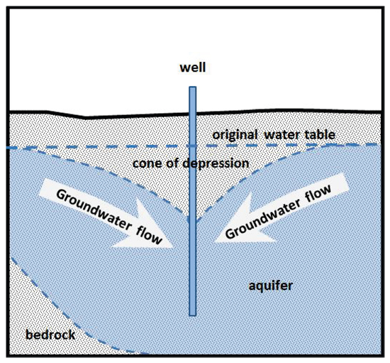
Water is removed from an aquifer using pumps and wells. Pumps use mechanical energy supplied by a drive motor or engine to force water toward the land surface. Removing water lowers the water level in the well. The difference between the initial water level, or static water level, and the pumping water level causes water to move within the aquifer. Since the water level always is lowest in the well, water from the surrounding aquifer flows toward the well to replace the water being removed.
When pumping starts, most of the water is removed from very near the well. With continued pumping, water is removed farther from the well, lowering the water level at a greater distance from the well. Drawdown decreases with the distance from the well until at some distance, the water level may remain relatively unaffected by pumping.
After many hours of pumping, the water level nearly stabilizes. The resulting cone-like shape of the groundwater is referred to as a cone of depression (Figure 4). The size and shape of the cone of depression is determined by the aquifer materials and the amount of water being removed from the aquifer. For example, private drinking water wells generally are pumped for short periods of time at rates of 5 to 20 gallons per minute. This results in small, poorly defined cones of depression. Even low-yield aquifers often can be developed for domestic uses.
 |
| Figure 4. Cone of depression resulting from pumping a well. |
Summary
Groundwater provides approximately 85 percent of the water used for human consumption in Nebraska. It is important to understand groundwater’s existence, movement, quantity, and quality when planning for a private drinking water well. The available water supply must be of sufficient quality and quantity to meet needs.
Acknowledgments
This publication is the result of a collaborative effort between the University of Nebraska–Lincoln Extension, the Nebraska Department of Health and Human Services, the Nebraska Department of Environmental Quality, the Nebraska Well Drillers Association, and the Nebraska On-site Waste Water Association, all of whom place a high priority on protecting Nebraska’s drinking water resources.
This publication contains information from the UNL Extension publications Understanding Groundwater (by William L. Kranz, Extension Irrigation Specialist; DeLynn R. Hay, Emeriti Extension Water Resources Specialist; and James W. Goeke, Emeriti Research Hydrologist) and So You Need a Water Well? which was prepared cooperatively by the Nebraska Well Drillers Association and the Conservation and Survey Division of the Institute of Agriculture and Natural Resources at the University of Nebraska–Lincoln.
Partial funding was provided by the Nebraska Well Drillers Association, the Nebraska On-site Waste Water Association, and the Water Well Standards and Contractors’ Licensing Board.
This publication has been peer reviewed.
Visit the University of Nebraska–Lincoln Extension Publications website for more publications.
Index: Water Management
Drinking Water
Issued May 2012