G1469
Residential Onsite Wastewater Treatment: Site Evaluation
This NebGuide, a cooperative effort by the Nebraska Onsite Wastewater Treatment Task Force, whose members are listed on the last page, discusses evaluation of a site to gather information that will
help determine the type and size of residential onsite wastewater treatment system best suited to that
location. It is recommended to select the location of the wastewater treatment system before finalizing house and well placement, since site characteristics may limit system options.
Jan R. Hygnstrom, Extension Project Manager
Sharon O. Skipton, Extension Educator
Wayne E. Woldt, Extension Specialist
- Site Evaluation — Before Visiting the Site
- Site Evaluation — Initial Evaluation at the Site
- Site Evaluation — Detailed Evaluation at the Drainfield Site
- Summary
The most common onsite wastewater treatment system for rural homes consists of a septic tank and drainfield. The success of an onsite wastewater treatment system depends largely upon soil characteristics, as well as system design, installation, and maintenance. This NebGuide will explain how to evaluate a site for a system and how to narrow the choices between different types of systems. For general information on how a septic tank/effluent treatment system works, see the NebGuides Residential Onsite Wastewater Treatment: Septic Tank Design and Installation (G1473), Traditional Drainfield Systems for Septic Tank Effluent Treatment (G1479), and Gravelless Drainfield Systems for Septic Tank Effluent Treatment (G1480).
Site Evaluation — Before Visiting the Site
A great deal of information is required to conduct a site evaluation. Much of it can be collected and organized before the onsite evaluation. Nebraska law states that Digger’s Hotline of Nebraska (811 or http://www.ne-diggers.com) must be contacted at least two business days before excavation. They will contact local utilities to mark registered electrical, gas, phone, fiber optics, cable, public water supply, and public sewer lines on the property. Following is a list of information needed to plan the site evaluation and where to find it.
- Topography (slope, surface drainage) from 7.5 minute USGS topographic maps, available from University of Nebraska–Lincoln (UNL) Conservation and Survey Division (CSD)
- Local setbacks (wells, property line, surface water, roads) available from local County Planning and Zoning office
- Soils from U.S. Department of Agriculture county soil surveys available from CSD and Natural Resources Conservation Service (NRCS)
- Legal description available from local Register of Deeds and County Planning and Zoning offices
- Easements, utilities available from local County Planning and Zoning office, and local utilities
- Legal requirements of design/installation available from local County Planning and Zoning office, and Nebraska Department of Environmental Quality (NDEQ).
- Flooding information available from NRCS
- Well location and depth available from the well driller and Nebraska Department of Natural Resources, Groundwater Section
Slope
Sites with a slope of less than 15 percent (15-foot drop in 100 feet of run) usually do not create a serious problem for constructing a traditional septic tank and drainfield system. Construction is more difficult and costly on steeper slopes. Drainfield trenches must be placed on the contour (Figure 1) to keep trenches from being too deep for oxygen to reach the wastewater treatment area; bacteria that treat wastewater need air. Slope can be estimated using a topographic map, available at UNL Conservation and Survey Division. Verify slope at the site using a transit, laser level, or 10-foot board and carpenter’s level.
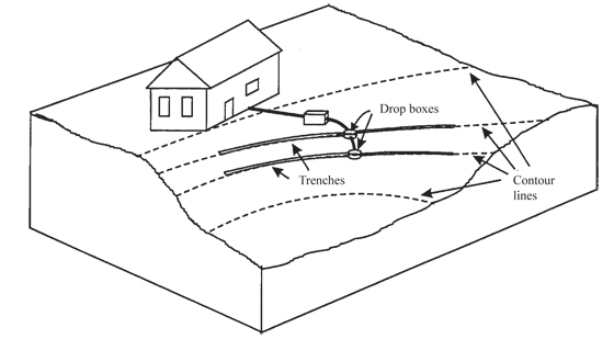 |
| Figure 1. Drainfield trenches on contour. |
Setback Distances
Nebraska Department of Environmental Quality Title 124, Rules and Regulations for the Design, Operation, and Maintenance of Onsite Wastewater Treatment Systems lists setbacks, or minimum distances, from septic tanks, drainfields, and lagoons to features listed in Table I. Check local codes; they may be more stringent. Maintaining setback distances will reduce the possibility of contaminating groundwater and surface water. In addition, following setback distances between a drainfield and buildings will help prevent rainwater off a roof from inundating and overtaxing the drainfield.
Consider the placement of the house, water supply well, onsite wastewater treatment system, and reserve area, as well as where neighbors have, or might place, these features. Thought should be given to potential areas for a driveway, garage, swimming pool, and other improvements.
| Table I. State minimum setback distances (local codes may be more stringent). | |||
| Item | Tanks | Effluent Treatment
Systems (Drainfields, etc.) |
Lagoons |
| Surface water Private drinking water wells |
50 ft 50 ft |
50 ft 100 ft |
50 ft 100 ft |
| Public drinking water wells:
Noncommunity system Community system |
50 ft 500 ft |
100 ft 500 ft |
100 ft 500 ft |
| Water lines:
Pressure-main Pressure service connection Suction lines |
10 ft 10 ft 50 ft |
25 ft 25 ft 100 ft |
25 ft 25 ft 100 ft |
| Trees: | No Setback | No Setback | 50 ft |
| Property lines: | 5 ft | 5 ft | 50 ft |
| Building foundations:
Class 1 foundations Class 2 foundations Class 3 foundations |
15 ft 10 ft 7 ft |
30 ft 20 ft 10 ft |
100 ft 100 ft 50 ft |
| Neighbors’ building foundations: Class 1 foundations Class 2 foundations Class 3 foundations |
25 ft 20 ft 15 ft |
40 ft 30 ft 20 ft |
200 ft 200 ft 100 ft |
| Class 1 foundations: Full basements or nonbasement footing foundations and slab on grade for living quarters that are lower in elevation than the onsite wastewater treatment system.
Class 2 foundations: Nonbasement footing foundations, trailer houses, and slab on grade living quarters that are higher in elevation than the onsite wastewater treatment system. | Class 3 foundations: Structures using slab on grade construction and are not used as living quarters. |
|||
Soil Characteristics
Soil plays a very important role in determining the type of wastewater treatment system best suited for a site. The county soil survey report is a valuable starting point for evaluating soil at a site. The survey report shows soil characteristics such as soil type, soil permeability, depth to bedrock, or seasonal high groundwater table; slope; and limitation ratings for drainfields. Soil survey reports may be available at local UNL Extension or NRCS offices, at CSD within the UNL School of Natural Resources or on the Internet. See the NebGuide Residential Onsite Wastewater Treatment Systems: The Role of Soil (G1468) for more detailed information on soils and the soil survey report.
Site Evaluation — Initial Evaluation at the Site
When preliminary information on slope, soils, and existing improvements has been collected, an onsite evaluation can be done. Begin with a scaled sketch of the site showing property lines and other features (Figure 2). The property owner should be present to discuss options and issues. Following is information on two important aspects of the site evaluation — looking at vegetation and the soil.
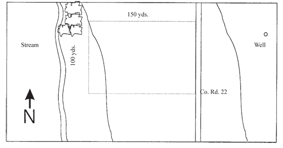 |
| Figure 2. Sketch of a site showing property lines and other features. |
Vegetation
Vegetation can provide clues about soil drainage and soil type. For example, cattails, reeds, and willows indicate wet soil areas. Record these on your sketch or map of the site.
Soil
An initial soil evaluation should provide information on soil characteristics, including seasonal high groundwater level. Alternate saturation and drying of soil results in discoloration or staining that is not part of the dominant soil color. These various shades of gray, brown, red, or yellow are called mottling. They show that groundwater has, at some point, been at that elevation, and remained long enough to cause a chemical reaction, changing the soil color. The highest groundwater elevation is assumed to be the highest point at which mottling is observed, regardless of whether water is present at the time of observation.
One method, or a combination of several can be used for an initial soil evaluation at the site. These include probing, augering, or digging a pit.
- Probing — A soil probe is a hollow tube that, when pushed into the soil and extracted, gives an undisturbed column of soil for viewing. Probes vary in length and diameter. Usually extensions can be added to probe deeper into the soil. It is the quickest method of looking at soil, and also allows you to detect faint soil mottling or cemented layers. Disadvantages are the relatively small diameter of the sample and inability to penetrate soil in rocky areas or under very dry conditions.
- Augering — Like a probe, an auger provides a column of soil for viewing when extracted. However, unlike a probe, an auger will disturb the soil sample. Auger diameters are typically larger than probes, and extensions can be added to access deeper into the soil. An auger produces larger samples and is more effective in rocky areas than a probe, although it still may be difficult to use due to rocks. Some disadvantages are that the auger is slower and more labor intensive, and the disturbed nature of the sample may not reveal faint mottles, cemented layers, or structure.
- Soil Pit — A pit is a dug-out area near the perimeter of an expected drainfield area. Do not dig a pit within the proposed drainfield area, as soil can settle after the system has been installed, disrupting the distribution lines. Sunshine should reach the sidewall during the observation period so subtle differences in soil color will be most visible. Soil pits provide the best method for viewing both undisturbed soil and how soil varies over the depth of the pit. Pits may be the only reliable method to determine depth to bedrock. However, digging a pit requires considerable manual labor or a backhoe, which can be costly. Safety is another consideration. Pits are especially hazardous in sandy soil or if excavated below the current water table depth. When digging, construct walls with a step-type configuration for safe entry and exit. Take appropriate safety precautions when working around the hole to prevent a cave-in, especially if sidewall soil is unstable or sandy. Heavy equipment or large objects such as boulders should not be allowed to rest on the surface immediately next to the pit sidewalls. Pits should be fenced to avoid falls or unauthorized entry, and backfilled as quickly as possible after use.
Site Evaluation — Detailed Evaluation at the Drainfield Site
The owner probably will have a potential building site selected. Select two or three appropriate areas for the onsite wastewater treatment system, keeping setback distances and slope in mind. Measure soil permeability with a soil percolation test. Note that in Nebraska, only a certified inspector, installer, soil evaluator, registered environmental health specialist, or professional engineer may conduct a percolation test for onsite wastewater treatment application. Check depth to bedrock and seasonal high groundwater at the area considered to be best suited for the wastewater treatment system. If conditions are unfavorable, try the next appropriate area for the treatment system. If that area is unsuitable, either select a different building site and site for the wastewater treatment system, or be prepared to consider an alternative system.
Soil Percolation Test
Soil percolation or perc tests are used to determine the ability of a soil to transmit wastewater effluent through the soil profile. The soil percolation rate is the amount of time it takes water to move through soil, measured in minutes per inch. Finer textured soils have slower percolation rates; it takes longer for water to drain from a test hole. These soil types need larger drainfields than soils with faster percolation rates, such as sandy soils, to handle a given amount of wastewater. Soils with very slow percolation rates may not be suitable for drainfields. In Nebraska, if soils perc at a rate slower than 60 minutes per inch, consider having a lagoon system installed if the lot is at least three acres. Otherwise, an engineer must design a specialized system. Soils with very fast percolation rates, less than five minutes per inch, must be modified by adding a loamy sand liner to the drainfield so that proper treatment can occur.
The Nebraska Department of Environmental Quality Title 124 requires that a percolation test be conducted to help determine the feasibility, type, and size of an onsite wastewater system. Title 124 specifies who may conduct a percolation test. In addition, some counties have a list of approved individuals. Contact your local health or planning department for requirements in your area. Specifics for conducting a perc test for onsite wastewater treatment application can be found in the NebGuide Residential Onsite Wastewater Treatment: Conducting a Percolation Test, (G1472).
Soil Borings
Borings help determine soil texture and properties, as well as depth to bedrock or seasonal high groundwater at the drainfield site. To do a soil boring:
- Locate the center of the proposed wastewater treatment system area.
- Make one soil boring, at least 5 to 6 feet deep and preferably 10 to 20 feet deep, noting changes in the soil.
- Estimate the maximum depth of the system (typically 20 to 66 inches of vertical depth), and make a written note of soil texture (proportion of sand, silt, or clay) at that depth.
- Make four additional borings at the system corners, 4 feet below the proposed depth of the system, and make a written note of soil texture and vertical depth to bedrock, and seasonal high groundwater if encountered at those locations.
Summary
Collecting and understanding site information is critical to selecting and installing the most appropriate onsite wastewater treatment system, and siting it in a location for best performance and longest life expectancy. Slope, setbacks, and soil characteristics must be evaluated. Soil permeability is an important soil characteristic to consider. Therefore, while determining where to construct any improvements, including buildings, a well, and an onsite wastewater treatment system, a professional must measure soil permeability with a soil percolation test and check depth to bedrock and seasonal high groundwater. The professional will use information gathered from the site evaluation, including the percolation rate, to select the most appropriate system and help determine the proper size and location for septic tank/drainfield systems.
Partial funding for materials development was provided by the U.S. Environmental Protection Agency Region VII and the Nebraska Department of Environmental Quality under Section 319 of the Clean Water Act (Nonpoint Source Programs).
This publication has been peer reviewed.
Visit the University of Nebraska–Lincoln Extension Publications Web site for more publications.
Index: Waste Management
Home Waste Systems
2002, 2006, Revised May 2011